Elly
Administrator
Posts: 29,887
|
Post by Elly on Dec 8, 2005 3:01:28 GMT 10
 Lanark is where the River Clyde begins the transition from the Southern Uplands to the Central Belt of Scotland. The town, like the river whose valley it overlooks, has one foot in the upland rural areas to the south, the other in the industrial heartland of Scotland to the north. Lanark itself is an attractive town. The St Nicholas parish church, though only dating back to 1774, is home to the world's oldest bell, cast in 1130. Lanark is perhaps best known for nearby New Lanark. This complex of cotton mills built along and powered by the River Clyde comes complete with its own village, still providing people with homes in the midst of a World Heritage Site. The Clyde Valley passes through extremely attractive countryside north of Lanark, and the signposted Tourist Route is well worth exploring. Other gems include secluded Craignethan Castle, on a bluff overlooking a tributary of the Clyde. Twelve miles east of Lanark is Biggar, a traditional market town serving a large but sparsely populated hinterland. The town itself is home to at least six seasonally open museums covering interests as diverse as the Covenanters, puppets, and vintage Albion trucks and buses. Another museum is housed in the UK's only remaining coal-fired gasworks. Near the centre of Biggar is the attractive Biggar Kirk, rebuilt in 1546. North east of Biggar the main A702 road generally follows the line of the Roman road built to serve the Roman fort at Musselburgh. En route it skirts the northern edge of the attractive village of West Linton. Further west lie the villages of Carnwath and Carstairs. South east of Biggar is one of Southern Scotland's finest viewpoints, the 23304ft or 711m high Tinto. To its south you can see a broad swathe of the Southern Uplands, complete, in the distance, with the ribbon of the M74 as it starts to wind its way through the hills towards its eventual destination of the English border. To Tinto's west, just beyond the M74, is the ancestral home of the Black Douglas family, Douglas. The uplands south west of Abington and Crawford offer some of the loneliest landscapes Scotland has to offer. One point of entry is via the B740 road through Crawfordjohn. Another is the A702 heading south towards Dumfries, whichis an excellent way to see a great deal of very little as you traverse the Lowther Hills. Another alternative for the more adventurous is to take the even higher road, through Wanlockhead. At 467m or 1531ft this is Scotland's highest village and only exists because of the lead found in these hills. No surprises, then to find it is the home of the excellent Museum of Lead Mining. Nearby Leadhills is home to the Leadhills and Wanlockhead Railway. History of Lanrkshire The Parish of Lanark covers more than ten thousand acres, much of it rich farmland. It includes both the ancient town of Lanark, one of the oldest royal burghs in Scotland, and the village of New Lanark. Lanark, a market town and the county town of Lanarkshire, is situated on high land overlooking the River Clyde. From the time of William the Lion, kings of Scotland came to hunt in the area. The royal castle where they lived stood on the mound at the foot of the Castlegate where there is now a bowling green. During the reign of David 1(1124-53) the monks of Dryburgh Abbey were given the old church of St. Kentigern around which the pre-Norman settlement is thought to have developed. Thereafter the Norman town grew up between the castle and the chapel of St. Nicholas, receiving its royal charter as a burgh in the same century. The ruins of St. Kentigerns are of considerable interest as they belong to this period. The end of the 13th century brought troubled times as many Scots took up arms against Edward I of England to maintain their independence. The noted Scottish patriot William Wallace gathered a body of supporters and slew the English sheriff in charge of Lanark Castle. This encouraged Wallace to fight on for the cause of Scotland. Although Wallace was later captured and executed, independence was achieved not long after by Robert the Bruce in 1314. Owing to the fact that several important burghs fell into English hands, Lanark was given the responsibility in 1369 of looking after the stone weights of Scotland. This reflected Lanark's importance as a market town. In both medieval and early modern times the Church in Lanark, as elsewhere in Scotland, dominated the life of the people. Although there seems to have been little unrest in the town at the time of the Reformation, Lanark was closely involved in the bitter struggle of the Covenanters. Following the Restoration in 1660, king Charles II sought by the introduction of Episcopacy to put an end to the Presbyterian form of church government. This heralded almost 30 years of repression, much of it brutal, causing the more extreme Covenanters to rise up in periodic rebellion against the forces of the government. The townspeople of Lanark were, rightly or wrongly, accused of encouraging the 'rebels' and were fined. Many people in the parish, such as William Hervey, who joined the Covenanting movement were executed and had their goods and property seized while others were imprisoned. Today, in their memory, there can be seen in St. Kentigerns churchyard an obelisk known as 'the Martyrs' Monument'. The Parish Church of St. Nicholas, originally a medieval chapel, became in 1688 the main church for the parish when the old St. Kentigerns fell into disrepair. The present rather plain building at the Cross was erected in 1774. Splits in the Church of Scotland culminating in 'the Disruption' in 1843 led ultimately to the erection in Lanark of some beautiful church buildings, several of which survive and are supported by loyal congregations. To cater for the growing number of Roman Catholics in the parish, St. Mary's Church, occupying a fine position at the top of the town, was opened in 1859 and subsequently rebuilt after a fire in 1907. In view of its importance, many of the nobility built dwellings in Lanark such as Hyndford House which dates back to the early 17th century. Later, in the 19th century, the establishment of rail links with both Glasgow and Edinburgh helped to give the town a new lease of life both as a commuter area and as a livestock market. As Lanark expanded, new streets were constructed and many graceful but substantial dwellings were erected within the burgh. Mainly due to the lack of economic minerals in the parish, Lanark escaped the worst ravages of the Industrial Revolution. As well as farming, which still thrives, craft trades such as boot and shoe making and handloom weaving continued well into the 19th century providing work for a large section of the population of the parish. Lanark is a town steeped in tradition. This is typified by the 'Lanimers' -a week long festival held early in June, which incorporates an inspection of the burgh boundaries as well as a beautiful pageant culminating in the crowning of the Lanimer Queen. The tradition of the pageant is first recorded in 1488 and the inspection of the 'marches' or burgh boundaries in 1570. Also, still marked every year on 1st March is the old custom of 'Whuppity Scoorie' when, at 6pm, as the parish church bell tolls, children race for a prize of money three times round the parish church swinging above their heads balls of tightly wrapped paper tied to the end of string. For nearly 400 years horses were raced at Lanark for one of the oldest and most coveted of racing trophies - the Lanark Silver Bell, sadly this is discontinued at the present. Set in a deep gorge by the River Clyde about a mile to the south of the town lies the village of New Lanark. It dates from 1785 when the first cotton mill was erected there by the merchant and philanthropist, David Dale. However, New Lanark is best known for the social experiment in communal living and working carried out in the early 19th century by Dale's son-in-law, Robert Owen, who acquired control over the village complex in 1800. His fame was such that the community drew to it visitors from all over Europe. As the years passed and as ownership of the village changed, work in the mills was diversified, until in 1968, it could no longer continue. To try to save the village, a conservation trust was formed and small businesses were set up. Today, now painstakingly and extensively restored, New Lanark attracts thousands of visitors from all over the world. |
|
Elly
Administrator
Posts: 29,887
|
Post by Elly on Dec 8, 2005 3:08:35 GMT 10
Lanark  St Nicholas Church Lanark lies high on the east bank of the River Clyde, close to its confluence with the Mouse Water. Its strategic location guarding the Clyde Valley was first recognised by the Romans, who built a fortification on what is now known as Castle Hill, an outcrop south west of the centre of the town which drops steeply into the valley. The Romans were followed by others in fortifying this site, and in 978 King Kenneth II held at least one Parliament here. Lanark Castle was later a residence of David I and William the Lion: and in 1140 David granted Lanark the status of a Royal Burgh. Under Alexander III, Parliaments met in Lanark in 1293, 1294 and 1295. The next chapter in Lanark's history is remembered by a plaque on a stone plinth set in an unpromising gap between two buildings facing across to St Nicholas' Church. It states: "Here stood the house of William Wallace who in Lanark in 1297 first drew sword to free his native land." "Braveheart" was a great film that did much for Scots' sense of identity: though at some cost to our sense of history. By July 1297 Wallace was already an outlaw. He was visiting his wife, Marion Braidfoot, and his baby daughter in Lanark when the English Sheriff, Sir William Heselrig, learned of his presence in the town. The English troops arrived from Lanark Castle to arrest him, but Wallace escaped after a fight. Marion Braidfoot did not, and Sir William Heselrig had her killed when she refused to say where Wallace was hiding. That same night Wallace and his men attacked and took Lanark Castle. Wallace killed Heselrig in his bed, then ordered the slaughter the entire English garrison. This was the spark that lit the revolt that culminated in the Battle of Stirling Bridge on 11 September 1297. Heselrig's death was later one of the charges laid against Wallace at his brief trial in London in 1305. Lanark Castle never developed beyond Heselrig's timber structure and in the late 1700s the site was turned into a bowling green. Which is how it remains today, the only evidence of its earlier life being a stone memorial and the very steep drops that fall away on three sides of the bowling green into the Clyde Valley. In more recent centuries Lanark has served as a focus for a wide rural community, and its livestock markets were particularly important. Perhaps the biggest change came from 1785 when the immense power of the water tumbling down the River Clyde in the valley below began to be harnessed by the vast cotton mills built at New Lanark, just a mile from the existing town. For the better part of 200 years the bustling community of New Lanark helped drive the local economy. But the mills closed in 1968 and by 1974 it was thought possible that the whole New Lanark development would have to be demolished. Instead it began a process of regeneration that led to its being granted World Heritage Site Status by UNESCO on 14 December 2001.  High Street  Site where Lanark Castle stood  popular Royal Oak Hotel |
|
Elly
Administrator
Posts: 29,887
|
Post by Elly on Jan 6, 2006 16:07:38 GMT 10
 Craignethan Castle Lanark lies high on the east bank of the River Clyde, close to its confluence with the Mouse Water. Its strategic location guarding the Clyde Valley was first recognised by the Romans, who built a fortification on what is now known as Castle Hill, an outcrop south west of the centre of the town which drops steeply into the valley.  The Hall  Stones on Display in Kitchen Tower  Tower Stairway  Caponier Interior Craignethan is a fascinating castle built in 1532 on a bluff falling steeply on two sides to the River Nethan and on a third to the Craignethan Burn. The only approach is from the higher ground to the west, and on this side the castle was protected by defences designed to withstand the strongest artillery of the day. This is a castle full of surprises, with far more to see and explore than you expect, and it makes an excellent half day out. Craignethan Castle lies a little to the west of the A72 near Crossford, a few miles north west of Lanark. Follow the brown tourist signs from the A72 as they take you on a magical mystery tour along some very steep and narrow roads through beautiful countryside. Craignethan Castle was built by Sir James Hamilton in 1532. He was a man with powerful enemies: a claim in 1540 that he had been involved in a plot against his friend James V many years earlier, though probably untrue, led to his execution for treason. Craignethan passed to the Crown, before being acquired in 1542 by another James Hamilton, 2nd Earl of Arran, half brother of the original builder, and Regent of Scotland. Hamilton pursued his personal ambitions with mixed success before and during the personal reign of Mary Queen of Scots. After her abdication, Hamilton and his family led the forces supporting Mary's claim to the Scottish Crown. In January 1570, this led to their arranging the shooting of the Earl of Moray, acting as Regent for the infant James VI. The Earl of Moray had briefly captured Craignethan Castle in 1568 after Mary's defeat at the Battle of Langside, but lost it to the Hamiltons again later the same year. In July 1570 and again in 1571 the Hamiltons launched abortive military coups from their bases at Craignethan Castle and Hamilton Castle. During the second of these the new Regent for James VI, Earl Lennox, was also killed . Hostilities paused in 1573, but in March 1578 James VI took personal control of the government at the age of 12. In May 1579 he moved against the Hamiltons and they were finally brought to account for their part in the deaths of James' two Regents in 1570 and 1571. Hamilton Castle was besieged for four days, and Craignethan Castle was expected to put up even stiffer resistance. But it was abandoned without a fight, and in the 1580s the main defences were demolished. Craignethan ceased to function as a castle after an active life of just 50 years. The tower house remained in use as a family residence, but was replaced in 1665 with a more modest and modern house in the south west corner of the outer courtyard by the castle's then owner, Andrew Hay. Craignethan Castle assumed new significance in the 1800s when it was associated in popular imagination with Tillietudlem Castle, from Sir Walter Scott's novel "Old Mortality". Despite his denial of the link, a nearby branch line railway station, built later in the 1800s, was named Tillietudlem Station. This interest led to repairs starting on the castle at the end of the 1800s, and in 1949 Craignethan Castle was placed in the care of the State. Today it is looked after by Historic Scotland. You approach Craignethan Castle on foot from the car park on the hillside to the west. As you see it laid out in front of you, your first impression is of the domestic buildings around the outer courtyard, and the tower house standing aloof beyond the defensive ditch. It comes as a surprise to find that there is a range of further buildings to the west of the tower house, and the tower house itself is unexpectedly complete and complex. The defensive ditch is also impressive, complete with a caponier in its bottom designed to allow defenders to shoot anyone getting that far. Your surprise at the apparent completeness of the castle can be misleading. A glance at the guide book or information boards shows that in its heyday the most striking feature of the castle would have been the massive west rampart, rising sheer from the ditch and thick enough and high enough to protect the tower house and everything beyond it from the best artillery available in 1532. This rampart was demolished in the 1580s, with much of the spoil filling the ditch. The caponier was therefore a huge surprise when it was unearthed during excavation of the ditch in 1964, still containing animal bones believed to be the remains of the last meal of the defenders who deserted it without firing a shot in 1579. |
|
Elly
Administrator
Posts: 29,887
|
Post by Elly on Jan 7, 2006 15:17:01 GMT 10
Strathaven 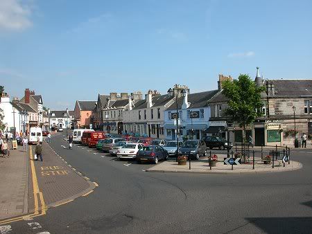 Strathaven sits astride the A71 Edinburgh to Kilmarnock road a few miles west of its junction with the M74 motorway. The focus of the town is Common Green, in effect the market place. As this lies to the north of the line of the A71 it is easy to drive without pause through Strathaven if your destination is further west. 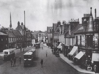 Common Green, pictured in 1930 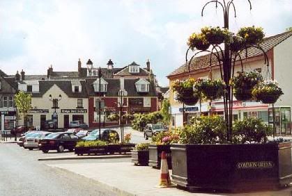 Common Green in the Year 2000 You also quickly get the idea that Strathaven has an interesting story to tell. The obvious clue is in the remains of the castle on a rocky outcrop looming over the main road. A stone castle was first built here in the 1300s, probably replacing an earlier wooden structure. By the 1400s Strathaven Castle was a possession of the Black Douglases, and it was amongst their castles destroyed by James II in 1455 when he suppressed this branch of the Douglas family. Strathaven Castle was rebuilt in 1458 by Sir Andrew Stewart, 1st Lord Avondale, and as a result it is sometimes called Avondale Castle. It later passed to the Hamilton family, but fell into disuse and disrepair after the death of Anne, Duchess of Hamilton in 1716. One of the towers was struck by lightning in 1736, and the roof blew off in a storm in 1737. This was taken by the townsfolk as a cue to start recycling the stone from the castle into other local building projects. Today's visitors to Strathaven Castle find the partial remains of a tower house built in the shape of a parallelogram, and probably originally five storeys high. The remains have at some point been consolidated by the liberal application of concrete to the inside of the main walls, giving the impression of a defensive structure of the 1940s rather than the 1450s. But the place still has a certain atmosphere and you can readily imagine this as the starting point of the various secret passages to different parts of the town that are reputed to exist, or the place where the wife of one Lord was entombed within the wall and left to die. Strathaven itself is remarkable for the number of brightly harled or pebbledashed buildings, giving the slightly surreal impression that you are walking through the set of a children's TV series. The overall effect of the collection of pinks, yellows, reds, blues and greens that dot the town is extremely attractive. 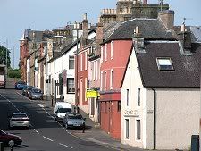 Kirk Street The town is also interesting for its extremely nice looking collection of pubs, many of which have also gone for the brightly coloured approach. As you look around this extremely well-kept town, you can't help wondering how it maintains such obvious economic vitality. 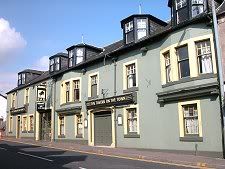 Tavern 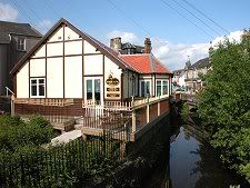 Rustichella Italian Restaurant The answer lies further north, in East Kilbride, whose dramatic growth over recent decades has had a positive impact on attractive places to live within easy commuting distance: and on Strathaven in particular. The rock on which Strathaven Castle is built is an excellent vantage point from which to view the town. Another is Kirk Hill, to the east, now the imposing home of Strathaven's war memorial. From either, the most significant features on the skyline are two spires. One is white and comes complete with a clock. This belongs to the East Parish Church, superbly located next to the Powmillon Burn at the end of Allison Green. The other is plain stone and belongs to the Rankin Church, a little to the west. 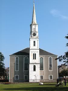 Strathaven East Parish Church  Strathaven Castle Dating back to the 14th century, Strathhaven had several owners. In the early 1400's, it was owned by the powerful Douglas family. After the suppression of the House of Douglas in 1455, it passed in 1458 to Sir Andrew Stewart, who later become the first Lord Avondale. The 3rd Lord lost it to Sir James Hamilton of Finnart in 1534. In 1611 Strathhaven was sold to James, 2nd Marquis of Hamilton and it remained in that family for three hundred years. An interesting story is told on the plaque outside the castle. According to tradition, the wife of a past lord so greatly displeased her husband that she was walled up alive in part of the Castle wall. Nothing is recorded of her crime, yet it is said that she was led into a small purpose-built niche, blessed by a priest, given some food and water, and then walled up forever. When a portion of the walls fell down in the middle of the 19th Century human bones were discovered, giving some credence to this story. |
|
Elly
Administrator
Posts: 29,887
|
Post by Elly on Jan 7, 2006 15:37:42 GMT 10
Roman Fort Bothwellhaugh, Lanarkshire The Bothwellhaugh Roman Fort At least two phases of construction was observed in the north-eastern rampart during excavations in 1967-8. These digs placed three main trenches across the north-eastern defences at widely-spaced points and another nine supplementary trenches to trace the defensive circuit. An attempt was also made to uncover the north-eastern gateway but unfortunately, and perhaps predictably, the planned excavations were severely curtailed due to the British climate 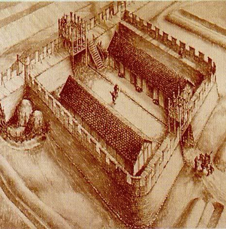 The fort lies to the East , and would probably have provided barrack accommodation for about 500 men. The rampart and ditches can be followed round the fort, and the over grown ruins of some of the more important buildings can still be seen. The Roman Bath-House The remains of a substantial Roman building were observed beside a haulage-track some 410 feet (125m) to the north-west of the fort on the east bank of the South Calder Water. A set of nine test pits dug in November 1973 uncovered evidence of a Roman bath-house, including flagstones, masonry, bricks flue-tiles, window glass and burned wattle-and-daub. The area covered by building debris extended about 80 ft (25m) north-south by 60ft (18.5m) east-west; a quite respectable bath-house is indicated. The recovery of fragments of a Form 33 samian cup confirms an Antonine date for the bath-house. 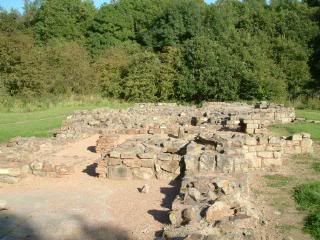 |
|
Elly
Administrator
Posts: 29,887
|
Post by Elly on Jan 7, 2006 15:49:42 GMT 10
The Antonine Wall In The Footsteps of the Emperors Falkirk's Roman Connections Almost 2000 years ago the Roman army invaded Britain under the Emperor Claudius. It was approximately 35 years later before they managed to penetrate Scotland, and they were never to conquer the Northerly areas of Britain. The area of Falkirk lies on the border of what would have been the most Northerly Frontier of the Roman Empire, and the most enduring memorial to the Roman presence here is the Antonine Wall, which was built around 142AD. Substantial lengths of this remarkable monument can still be seen at various sites in the Falkirk area today. 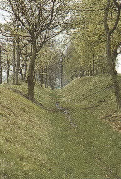 WATLING LODGE - Tamfourhill Here you will find the best surviving stretch of the Antonine Wall, which gives the clearest impression of the formidable nature of the ditch. It is still about 40 feet wide and 15 feet deep. The remains of the turf rampart can be seen as a low mound set back some 20 feet South of the ditch. The siting of the Wall at this position gave an unobstructed view of the countryside to the North. Background To The Building Of The Antonine Wall The Roman invasion of 'Caledonia' (Scotland) was led by the Roman Governor of 'Britannia' Agricola, who, within 7 years had managed to conquer Southern Britain and penetrate right into the heart of Caledonia. In AD82 he defeated the Picts, led by the warrior Calgacus, at the battle of Mons Graupius, one of the biggest land battles ever fought on Scottish soil. However, the Romans found it difficult to hold onto the Northern areas, and Agricola withdrew to the South before being recalled to Rome. Continuing problems with the Northern 'barbarians' prompted the Emperor Hadrian to visit Britain in AD122, and he ordered a wall to be built to separate the barbarians from the Roman Empire, and to prevent the Picts from raiding Roman settlements in the Southern half of Britain. This wall, known as Hadrians Wall, was 73 miles long, and stretched from the Tyne to the Solway Firth. Antoninus Pius - builder of the Antonine Wall However, on the accession of the Emperor Antoninus Pius in AD138, it was decided to once again extend the Northern Frontier, and an order was given to advance into Caledonia. He then ordered another wall to be erected, the Antonine Wall, which was to become the most Northerly frontier of one of the most vast and powerful Empires mankind has ever seen. 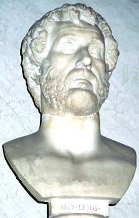 Antoninus Pius - builder of the Antonine Wall The Wall Itself The Antonine Wall was erected around 142AD, and stretched from the Carriden on the Forth, to Old Kilpatrick on the Clyde, and was approximately 37 miles long. Unlike the stone built Hadrians Wall, the Antonine Wall consisted of a rampant of soil faced with turf, resting on a stone foundation. It originally stood 12 feet high, and was protected on the North by a V shaped ditch 40 feet wide and 12 feet deep. South of the wall itself ran a cobbled road, the 'Military Way' which linked a network of forts that were built along the wall at intervals of approximately 2 miles. These forts acted as barracks for troops who defended the frontier. The Wall was constantly being attacked by the Picts, and as the Roman Empire gradually became weaker, the Romans were forced once again to withdraw back to Hadrians Wall. Eventually, because of turmoil in the Empire, the Romans abandoned Hadrians Wall and withdrew from Britain after almost 250 years of occupation. 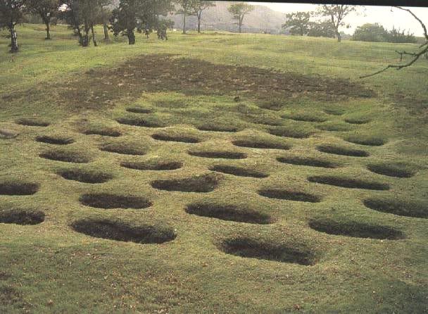 Over the causeway across the Antonine ditch, lies a series of pits called 'lilia'. These originally had a pointed stake at the bottom of each to serve as a trap for anyone attacking the fort. 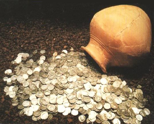 Pot containing over 2000 Roman coins found in Falkirk. There are also a number of other less well preserved sites within the Falkirk area, where there are interpretative display panels to describe each location for visitors. These are located at Kemper Avenue, Anson Avenue and Tamfourhill Road in Falkirk, and Castlecary. The museums at Falkirk and Kinneil also house an extensive collection of finds, including pottery, jewellery, weapons and clothing which have been uncovered from sites around the route of the Antonine Wall. |
|
|
|
Post by andi on Jan 7, 2006 21:17:01 GMT 10
Great information and pics, Elly!
|
|
|
|
Post by smudger on Jan 7, 2006 23:02:51 GMT 10
Lol thanks for the info about the Roman forts and walls i love to read about the Romans . Even more so in their campaigns in Caladonia .
|
|
Elly
Administrator
Posts: 29,887
|
Post by Elly on Jan 8, 2006 16:38:57 GMT 10
I`ve learned a bit myself doing it, it`s very interesting #tartanberet#
|
|
Elly
Administrator
Posts: 29,887
|
Post by Elly on Jan 19, 2006 15:16:31 GMT 10
Motherwell  North Lanarkshire Council Offices The large town of Motherwell lies on the east side of the Clyde Valley and of the M74 motorway a dozen miles south east of Glasgow. It's difficult to believe today, but until the arrival of the railway in the 1830s Motherwell barely existed. There had certainly been people living in the area from a very early date. The name comes from an ancient religious well, the Mother's Well, dedicated to the Virgin Mary. Today its site is marked by nothing more than a plaque in Ladywell Road. Even further back in time, the Romans ran their main road to central Scotland along this side of the Clyde Valley, crossing the South Calder Water at a spot on the north west side of today's Motherwell. Here they built a fort and a bath house, though they didn't stay in Scotland for long. So, by the 1830s, the area comprised assorted farming communities and the estate of Jerviston House, plus a tiny hamlet called Motherwell around the crossroads between the road following the Clyde, and the one running from Edinburgh to Hamilton and beyond. And then the railways arrived and everything changed. The first to arrive did so in 1833, and from 1849 Motherwell became a junction station with a direct link to Glasgow. Another line was added in the 1870s, crossing the Clyde. The town's excellent communication links led to the development of a number of major iron and steel works on the north east side of the town. A wide range of other heavy engineering companies were established in the same area, building everything from munitions (a good business to be in during the First World War), to bridge components, to trams. By the 1930s most of Scotland's steel production, including that in Motherwell, was in the hands of the Coleville family, and it remained so until the steel industry was nationalised in 1967. In 1959 the government persuaded the Colevilles to begin work on a vast new steelworks, which was to become Ravenscraig, occupying much of the land to the north east of Motherwell. By 1961, 1.2 million tonnes of iron was emerging from Ravenscraig's blast furnaces: more than the total production of Scotland's industry in the 1800s. After nationalisation of the industry, the British Steel Corporation raised production of the blast furnaces further, producing 3 million tonnes each year from the early 1970s. By the mid 1970s employment in BSC's various plants on the east side of Motherwell reached 13,000 people. The 1980s brought catastrophic decline. The steel strike of 1980 lost BSC important markets, and this was followed by the closure of the Linwood car factory in 1981 and the Bathgate truck factory in 1986, both very important customers. By 1989 Ravenscraig employed just 3,200 people. Worse was to follow. 400 years of Scottish ironmaking came to a close on 24 June 1992, when Ravenscraig closed: the iconic gasholder bearing the Ravenscraig name was demolished in July 1996. Today only the Dalzell Plate Mill remains of Motherwell's once thriving iron and steel industry, employing several hundred people rolling steel brought by train from Middlesbrough into plate steel of various shapes and sizes. The huge area once occupied by the Ravenscraig Steelworks has been steadily cleaned of industrial pollution and seems likely to end up being reused to provide a new regional centre, significantly expanding the Motherwell you see today. And that is a Motherwell that has moved on from its reliance on heavy industry: though as a visit to its beautiful new Heritage Centre shows, without forgetting its past.  Motherwell Heritage Centre  The Brandon Centre  South Dalziel Parish Church  Roman Catholic Cathedral  Town Centre |
|