|
|
Post by andi on Feb 15, 2007 9:39:52 GMT 10
Eileach an Naoimh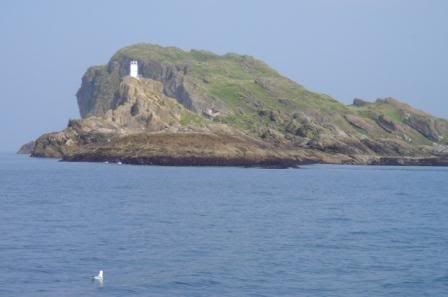 Eileach an Naoimh is an uninhabited island in the Inner Hebrides of the west coast of Scotland. It is the southernmost of the Garvellachs archipelago and lies in Firth of Lorne between Mull and Argyll at grid reference NM645095. The name is Gaelic for rocky place of the saint. In 542, St. Brendan the Navigator founded a monastery on the island. The monastery was destroyed several centuries later by Viking invaders. The island has probably been unoccupied since, which has contributed to the survival of the ruins of many of the monastic buildings, including the chapel, beehive cells, and the graveyard. These are now in the care of Historic Scotland. en.wikipedia.org/wiki/Eileach_an_Naoimh
|
|
|
|
Post by andi on Feb 15, 2007 9:42:22 GMT 10
Eilean Dubh Mòr Eilean Dubh Mòr (Gaelic: for big black island), is an uninhabited island in Inner Hebrides of Scotland. It lies at the mouth of the Firth of Lorne, between the islands of Lunga and Garbh Eileach at grid reference NM695105 en.wikipedia.org/wiki/Eilean_Dubh_M%C3%B3r
|
|
|
|
Post by andi on Feb 15, 2007 9:44:48 GMT 10
Eilean RighEilean Righ is an island in the Inner Hebrides of the west coast of Scotland. It lies in Loch Craignish, about 300 m off Argyll coastline at grid reference NM805015. The name is Scottish Gaelic for "King's Island", although which royal is not known. In the 1930s, the island was home to Sir Reginald Johnston, retired tutor to Puyi, the last Chinese emperor. Johnston modernised the houses, built a Buddhist temple and even flew the Manchurian flag in the Chinese-style gardens. The current owner is a London-based city trader, Christian Siva-Jothy, who made his fortune cashing in on the financial impact of the September 11 attacks on the World Trade Center [1]. There is also a similarly-name islet, Eilean an Righ south of the isle of Ulva grid reference NM397380 en.wikipedia.org/wiki/Eilean_Righ
|
|
|
|
Post by andi on Feb 15, 2007 9:46:54 GMT 10
Eorsa Eorsa is an uninhabited island in the Inner Hebrides of Scotland. It lies in Loch na Keal on the west coast of the Isle of Mull. The island is the fictional setting of Nigel Tranter's 1952 novel Bridal Path, which was made into film of the same name in 1959. As the comic novel takes the perils of island inbreeding as its theme, it is assumed that Tranter deliberately chose an unpopulated island to avoid giving offence. en.wikipedia.org/wiki/Eorsa
|
|
|
|
Post by andi on Feb 15, 2007 9:51:33 GMT 10
Erraid The Isle of Erraid is a tidal island approximately one mile square in area located in the Inner Hebrides of Scotland. It lies west of Mull (to which it is linked by a beach at low tide) and southeast of Iona. The island receives about 100 cm of rain and 1,350 hours of sunshine annually, making it one of the driest and sunniest places on the western seaboard of Scotland. It is attended by numerous uninhabited small islets, the largest being Eilean Dubh (of which there are two), Eilean nam Muc, Eilean Chalmain, Eilean Ghomain and Eilean na Seamair. The island features a disused signal station for the lighthouses on Dhu Heartach and Skerryvore and a row of cottages built for the lighthouse keepers. Erraid is one of the locations featured in the novel Kidnapped by Robert Louis Stevenson. David Balfour, the hero of this tale was marooned for a while on the island having been shipwrecked on the Torran Rocks, which lie to the south. Stevenson's father, Thomas was involved in the construction of the nearby lighthouses, and the stones for Dhu Heartach were quarried on the island. The young Robert Louis visited the island on several occasions, recalling one such excursion in his book Memories and Portraits and setting a short story, The Merry Men there. Satish Kumar has also visited the island and his autobiography includes an account of the event. The island is privately owned and is home to an Intentional community, part of the Findhorn Foundation. There is a well-known anchorage on the western side of the island called 'Tinker's Hole'. It is a deep but narrow channel between Erraid and the westernmost of the islets called Eilean Dubh. en.wikipedia.org/wiki/Erraid
|
|
|
|
Post by mcnass on Feb 15, 2007 20:02:38 GMT 10
There are so many wonderful islands - thank you, Andi.  I wonder if they all can be reached by ferry... |
|
|
|
Post by andi on Feb 15, 2007 20:25:00 GMT 10
|
|
|
|
Post by mcnass on Feb 15, 2007 21:56:16 GMT 10
60 Km to paddle? I'm no dolpfin... however, maybe....  |
|
|
|
Post by andi on Feb 16, 2007 0:07:49 GMT 10
Keeps you fit and healthy #happy#
|
|
|
|
Post by mcnass on Feb 16, 2007 0:27:34 GMT 10
 ==> 
|
|
|
|
Post by andi on Feb 17, 2007 4:06:50 GMT 10
Garbh Eileach Garbh Eileach is an uninhabited island in the Inner Hebrides of the west coast of Scotland. It is the largest of the Garvellachs and lies in the Firth of Lorne between Mull and Argyll at grid reference NM665115. The name is Gaelic for rough rocky mound. The Anglicised version of the name gives the whole group of islands its name, the Garvellachs. en.wikipedia.org/wiki/Garbh_Eileach
|
|
|
|
Post by andi on Feb 17, 2007 4:11:56 GMT 10
Gigha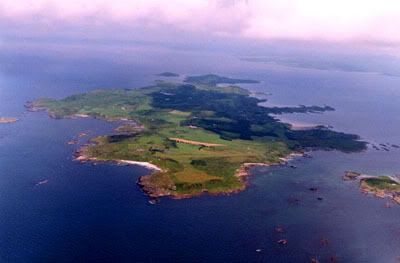 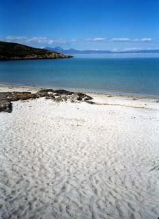 The Isle of Gigha (pronounced gee'a) is a small island off the west coast of Kintyre in Scotland. The island forms part of Argyll and Bute and has a population of about 150 people. The name is derived from the Norse Gudey meaning 'Good Island' or 'God Island'.[1] It is also the ancestral home of the Clan MacNeill, which possesses its own tartan and Clan badge, both distinctly different from the larger and better known Clan MacNeil of Barra (spelt with one L), but sharing the same Chief.[citation needed] The island is 9.5 km (6 miles) long in a roughly north-south direction and a maximum of 2.5 km (1.5 miles) wide. The total area is 1,395 ha (3,447 acres). Gigha is known for its Ayrshire cattle and goat's cheese. Other attractions on the island are the Achamore Gardens, begun in 1945 by Sir James Horlick[1] and known for its rhododendrons and azaleas, the many sandy beaches and the thirteenth century St Catan's Chapel ruins. Relative to its size it is the most fertile and productive island in Scotland.[1] There is an unmanned grass landing strip running east/west near the southern end of the island, requiring prior permission for landing. It is one of the closest airstrips to Glasgow International Airport at typically a twenty to thirty minute flight for small aircraft. A Caledonian MacBrayne ferry service links the island's only village, Ardminish, to Tayinloan on the Kintyre peninsula of the Scottish mainland. In the eighteenth century the population of Gigha peaked at over 700, but by the 1960s it had fallen to 163 and by the beginning of the 21st century it was down to only 98.[2] During the 20th century the island had numerous owners, which caused various problems in developing the area. This came to an end in March 2002 when the islanders managed, with help from grants from the National Lottery and Highlands and Islands Enterprise, to purchase the island for £4 million and they now own it through a development trust called the Isle of Gigha Heritage Trust. As a result March 15th, the day when the purchase went through[3], is celebrated as the island's independence day. In October 2006 it was announced[2] that the population had reached 150 - a rise of more than 50 per cent since the 2002 buy-out. Willie McSporran, chairman of the Heritage Trust, was quoted as saying: "The trust turned 300 years of population decline on its head by encouraging new development and the growth of the local economy. A sign of the surge of people wanting to relocate to Gigha is that we are struggling to meet the demand for housing despite building 18 new homes." The issues of island ownership are not unique to Gigha and consequently the island has been highlighted in an edition of the BBC series, Countryfile, which is the principal television forum for countryside issues in the United Kingdom. The Heritage Trust set up Gigha Renewable Energy Ltd. to buy and operate three Vestas V27 wind turbines, known locally as The Dancing Ladies or Faith, Hope and Charity. Since they were commissioned on 21 January 2005, they are capable of generating up to 675 kW of power. Revenue is produced by selling the electricity to the grid via an intermediary called Green Energy UK. Gigha residents control the whole project and profits are reinvested in the community.[4] References 1 ^ a b c Murray, W.H. (1977) The Companion Guide to the West Highlands of Scotland. London. Collins. 2 ^ a b Ross, J. (13.10.2006) Island of opportunity welcomes a population explosion. Edinburgh. The Scotsman newspaper [1] 3 ^ Island officially changes hands, BBC News Online, 15 March 2002 4 ^ Green Energy press release Retrieved 01.02.2007. en.wikipedia.org/wiki/Gigha
|
|