|
|
Post by andi on Feb 4, 2007 23:16:36 GMT 10
The HebridesThe Hebrides (Gaelic: Innse Gall) comprise a widespread and diverse archipelago off the west coast of Scotland, and in geological terms are composed of the oldest rocks in the British Isles. They can be divided into two main groups: Inner Hebrides, including Skye, Mull, Islay, Jura, Staffa and the Small Isles Outer Hebrides, including Lewis and Harris, Berneray, North Uist, South Uist, Barra and St Kilda The Hebrides as a whole are sometimes referred to as the Western Isles, but this term is more accurately applied just to the Outer Hebrides. The Hebrides are probably the best-known group of Scottish islands, but other groups include the islands of the lower Firth of Clyde and the Northern Isles. The islands in the Clyde, especially Arran, are sometimes mistakenly called Hebrides too. The Hebrides, also known as Fingal's Cave, is a famous overture written by Felix Mendelssohn while residing on these islands. The majority of native Scottish Gaelic speakers live on, or come from, the Hebrides. Ironically, given the status of the Western Isles as the last Gàidhlig speaking stronghold in Scotland, the Gaelic language name for the islands - Innse Gall - means "Isles of the non-Gaels" which has roots in the time when they were under Viking occupation. Sabhal Mòr Ostaig, the Gaelic college is based on Skye and Islay. Especially on the Outer Hebrides, the language is still very viable. en.wikipedia.org/wiki/Hebrides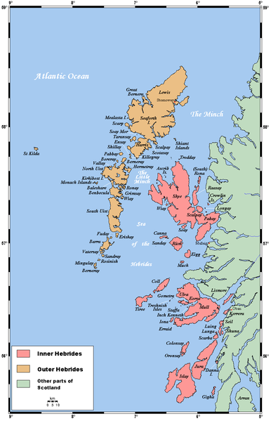
|
|
|
|
Post by andi on Feb 4, 2007 23:22:56 GMT 10
Inner HebridesThe Inner Hebrides (Scottish Gaelic: Na h-Eileanan a-staigh - the inner isles) is an archipelago off the west coast of Scotland, to the south east of the Outer Hebrides. They are part of the Hebrides. In classical sources, they are referred to as the Ebudae or the Ebudes. Traditionally, the Inner Hebrides have been subdivided into two groups (northern and southern). The Hebrides began to come under Norse control and settlement already before the 9th century AD. The Norse control of the Hebrides was formalized in 1098 when Edgar of Scotland formally signed the islands over to Magnus III of Norway. The Scottish acceptance of Magnus III as King of the Isles came after the Norwegian king had conquered the Orkney Islands, the Hebrides and the Isle of Man in a swift campaign earlier the same year, directed against the local Norwegian leaders of the various islands. By capturing the islands Magnus III subdued the Norsemen who had seized the islands centuries earlier and imposed a more direct royal control. The Norwegian control of both the Inner and Outer Hebrides would see almost constant warfare until being ultimately resolved by the partioning of the Western Isles in 1156. The Outer Hebrides would remain under the Kingdom of Mann and the Isles while the Inner Hebrides broke out under Somerled, the Norse-Celtic kinsman of both Lulach and the Manx royal house. Although the Inner Hebrides, from 1156 known as the Kingdom of the Hebrides, still nominally was under the sovereignty of Norway, the leaders were Scottish in language and culture rather than Norse. After his victory of 1156 Somerled went on to two years later seize control over the Isle of Man itself and become the last King of the Isle of Man and the Isles to rule over all the islands the kingdom had once included. After Somerled's death in 1164 the rulers of Mann would no longer be in control of the Inner Hebrides. The Lord of the Isles would continue to rule the Inner Hebrides as well as part of the Western Highlands as a subject of the King of Scots until John MacDonald, fourth Lord of the Isles, squandered the family's power away. Through a secret treaty with Edward IV of England in 1462, he planned to make himself more or less an independent ruler. When James III of Scotland found out about the treaty in 1475, he forfeited MacDonald's lands. Some were restored for a promise of good behaviour, but MacDonald was unable to control his son who defeated him at the Battle of Bloody Bay (Mull, 1481) and his nephew whose rebellion in 1493 provoked an exasperated James IV to forfeit the lands for the last time in 1493. MacDonald died in 1503. Northern IslandsThe northern Inner Hebrides comprise Skye, the Small Isles and some smaller islands surrounding Skye. They are part of the Highland unitary council region. The smaller islands include: Ascrib Islands Crowlin Islands Isay Longay Ornsay Raasay Pabay Scalpay, Soay, South Rona Wiay SouthernThe southern Inner Hebrides comprise Mull, Islay, Jura, the Slate Islands, the Treshnish Islands and some islands surrounding Mull. They are part of the Argyll and Bute council region. The smaller islands include: Calve Island, Cara, Carna, Coll, Colonsay Eileach an Naoimh, Eilean Dubh Mór, Eilean Macaskin, Eilean Righ, Eorsa, Erraid Garbh Eileach, Gigha, Gometra, Gunna, Shuna Iona, Inch Kenneth Kerrera Lismore, Little Colonsay, Luing, Lunga Oronsay Scarba, Seil, Shuna, Staffa Texa, Tiree Ulva en.wikipedia.org/wiki/Inner_Hebrides
|
|
|
|
Post by andi on Feb 4, 2007 23:31:17 GMT 10
Isle of Skye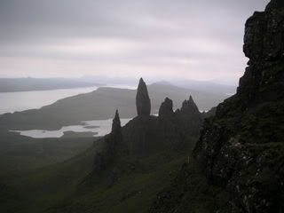 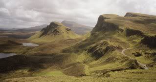 The Isle of Skye, usually known simply as Skye (An t-Eilean Sgitheanach in Scottish Gaelic), is the largest and most northerly island in the Inner Hebrides of Scotland. In Scottish Gaelic "sgiath" means "winged". Its name came via Old Norse Skið = "sky" (and similar meanings), as an alteration of a Pictish original which is recorded in Roman sources as Scitis (Ravenna Cosmography) and Scetis (on Ptolemy's map). Some legends associate the isle with the mythic figure of Scáthach. The island is sometimes also known as Eilean a' Cheò - or "Isle of Mist". The population of Skye, at the 2001 census was 9,232. In contrast to many other Scottish islands this represents a 4% increase from the census of 1991 [1]. The resident population is augmented in the summer by large numbers of tourists and visitors. The main industries are tourism, agriculture, whisky-distilling, brewing and craftmaking. The main town and capital of the island is Portree, which is known for its picturesque harbour. Skye is renowned for its spectacular scenery, vibrant culture and heritage, as well as its abundant wildlife including the Golden Eagle, Sea Eagle, Red Deer and the Otter. The Isle of Skye is the homeland of the people who first inhabited Skye Glen, Nova Scotia, close to the village of Whycocomagh. CultureOf all the Inner Hebrides, Skye has the most in common with the Outer Hebrides, with nearly half the population speaking Gaelic, and many belonging to the Free Church of Scotland, known for its strict observance of the Sabbath. Shinty is a highly popular sport, although football is widely played as well. Portree based Skye Camanachd won the Camanachd Cup in 1990.[citation needed] The Talisker Distillery, which produces a single malt whisky, is beside Loch Harport on the west coast of the island. There is also a famous blend called Isle of Skye, produced by MacLeod's. Dunvegan Castle has been the seat of Clan MacLeod since the thirteenth century. The Isle of Skye has been immortalised in the traditional song The Skye Boat Song and in the book To the Lighthouse by Virginia Woolf. Skye has a strong folk music tradition, although in recent years dance and rock music have been growing in popularity on the island. Gaelic Rock Band Runrig started in Skye and former singer Donnie Munro still lives in Portree.[citation needed] The Isle of Skye Music Festival has been growing in recent years and this year featured sets from The Fun Loving Criminals and Sparks. Mylo was born in Skye and frequently returns there to play sets. Sorley MacLean lived much of his life on Skye. TransportSkye is linked to the mainland by the Skye Bridge, while ferries sail from Armadale on the island to Mallaig, and from Kylerhea to Glenelg. Ferries also run from Uig to Tarbert on Harris and Lochmaddy on North Uist, and from Sconser to Raasay. Ferries to and from Armadale are sometimes synchronised with train arrivals and departures at Mallaig. The Skye Bridge, linking Skye with the mainland of Scotland, opened in 1995 under a private finance initiative. The high tolls charged (£5.70 each way for summer visitors) met with widespread opposition, spearheaded by the pressure group SKAT (Skye and Kyle Against Tolls). On 21 December 2004 it was announced that the Scottish Executive had purchased the bridge from its owners and the tolls were immediately removed. Bus services run to Inverness and Glasgow, and there are infrequent local services on the island, mainly starting from Portree or Broadford. Train services run from Kyle of Lochalsh at the mainland end of the Skye Bridge to Inverness. There is also a small aerodrome at the south of the island, which is used exclusively by private aircraft. The A87 trunk road traverses the island from the Skye Bridge to Uig, linking most of the major settlements. Many of the island's roads have been widened in the past 40 years, but there are still substantial sections of single track road. en.wikipedia.org/wiki/Isle_of_Skye
|
|
|
|
Post by andi on Feb 4, 2007 23:33:49 GMT 10
Ascrib Islands The Ascrib Islands are a group of small islands lying in Loch Snizort off the northwest coast of Skye, in Highland, Scotland. Together with Isay and Loch Dunvegan, they are designated as a Special Area of Conservation owing to the breeding colonies of the common seal. The islands are owned by Lord Palumbo. en.wikipedia.org/wiki/Ascrib_Islands
|
|
|
|
Post by andi on Feb 4, 2007 23:37:48 GMT 10
Crowlin Islands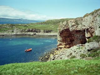  The Crowlin Islands (gaelic: crò linne) a group of uninhabited islands in the Inner Hebrides of Scotland. They lie between Skye and the Applecross peninsula on the mainland. The individual islands are: Eilean Mór (big island) Eilean Meadhonach (middle island) Eilean Beag (little island) Although cave excavations on Eilean Mór have shown evidence of human settlement in Mesolithic times 8,000 years ago, the islands have been uninhabited since about 1920. From about 1810 to 1920 Eilean Mór was home for several families, evicted from Applecross, but unwilling to take passage from Scotland to far-off lands. By agreement with the evicting landowning family they were allowed to settle on the islands and make what living they could by fishing and farming. en.wikipedia.org/wiki/Crowlin_Islands
|
|
|
|
Post by andi on Feb 4, 2007 23:40:45 GMT 10
Isay Isay is an uninhabited island in the Inner Hebrides of the west coast of Scotland. It lies in Loch Dunvegan, 1 km off the northwest coast of the Isle of Skye at grid reference NG215575. Two smaller isles of Mingay and Clett lie nearby. The name originated from the Old Norse ise-øy meaning porpoise island. In the early 19th century, the island had a population of around 90 and had its own general store and fishing station. However, like many other small islands, the island people were removed during the Highland clearances to make way for sheep. The island was briefly owned by the singer Donovan in the 1980s. en.wikipedia.org/wiki/Isay
|
|
|
|
Post by andi on Feb 4, 2007 23:47:24 GMT 10
Raasay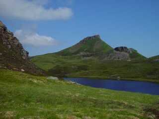  Raasay (Scottish Gaelic: Ratharsair) is an island between the Isle of Skye and the mainland of Scotland. It is separated from Skye by the Sound of Raasay and from Applecross by the Inner Sound. It is most famous for being the birthplace of the poet Sorley MacLean, often seen as being part of the Scottish Renaissance. "Raasay" means Isle of the Roe (or Red) Deer. It is sometimes written "Ratharsaigh" in Gaelic, but this is really a Gaelicisation of the English; the proper Gaelic is "Ratharsair", and appears in Sorley MacLean's writings. About fourteen miles (22.5 km) north to south and three miles (5 km) east to west (at its widest), its terrain is varied. The highest point at 1456 feet (443 m) is Dun Caan, an unusual, flat-topped peak. The small island of South Rona lies just off the north coast. The main village of Inverarish is near the southwest coast. A portion of the village served as a prisoner-of-war camp for Germans during the World War I. The prisoners were used to work the iron mine on the island (inactive since 1919). The primary employment is in tourism, working for the ferry company, or commuting to jobs on Skye. There is a primary school, but older students go to Portree via ferry and bus. Sites of interest include the remains of a broch, the ruins of Brochel Castle, inscribed stones, the old manor house – Raasay House – visited by James Boswell and Samuel Johnson, abandoned crofting communities, and many walking paths. The two miles of road between Brochel Castle and Arnish were built using handtools by Calum MacLeod BEM over ten years. Only when complete was the road surfaced by the local council; by then Calum and his wife were the last inhabitants of Arnish. Calum's Road has been commemorated in song (Capercaillie 1987) and in word (Roger Hutchinson 2006) who is also manager of the local football team. A fifteen-minute ferry ride connects the island with Sconser on Skye. An excellent small shop/post office is located in Inverarish. Accommodation is available at the Isle of Raasay Hotel, the Raasay Outdoor Centre (located in Raasay House), a B&Bs, and the Scottish Youth Hostels Association hostel, Creachan Cottage. There are significant numbers of incomers and holiday homes especially in the north of the island. This has helped to arrest the population decline from over 900 in 1803 to 194 in 2001. Some inhabitants belong to the Free Presbyterian Church of Scotland who strictly observe the Sabbath; there are no services on Sundays, the playground is closed, and (until 2004) the ferry did not run. Geologically interesting, the island is visited by many students engaged in mapping projects. The south is mainly Torridonian sandstone and shale; the north is Archaean gneiss. Raasay is home to the Raasay vole (Clethrionomys glareolus erica), a subspecies of Bank Vole, which is darker and heavier than the mainland variety and found nowhere else in the world. It also supports a rich variety of plants, Golden Eagles, Red Deer, a good otter population and a very large population of grey rabbits. It is also regularly visited by Sea Eagles. Raasay was ruled by the MacLeods from 1518; their initial stronghold being Brochel Castle. Although Protestant, they supported Bonnie Prince Charlie in 1745. After the defeat at Culloden, the original Raasay House and many dwellings were burnt down by government troops. In 1843 the last laird, John Macleod, was deep in debt and chose to emigrate to Australia. Subsequently the island was bought by private individuals for sporting purposes until acquired in 1912 by Baird & Co. who opened the mine. Since 1922 much of the island has been owned by the government. en.wikipedia.org/wiki/Raasay
|
|
|
|
Post by andi on Feb 4, 2007 23:52:10 GMT 10
Scalpay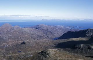  Scalpay is an island in the Scottish Inner Hebrides separated from the east coast of Skye by Loch na Cairidh. Its highest point is Mullach na Carn at over 400 metres. Scalpay is privately owned and operates a red deer farm, shooting estate and holiday cottages. Much of Scalpay is covered with heather, while other areas are conifer forestry plantations. Shipping magnate and politician Donald Currie owned the island in the late 19th century and was responsible for the construction of the first roads and much tree planting. en.wikipedia.org/wiki/Scalpay%2C_Inner_Hebrides
|
|
|
|
Post by andi on Feb 4, 2007 23:54:12 GMT 10
Soay Soay is an island just off the south coast of Skye, in the Inner Hebrides of Scotland. The main settlement is Mol-chlach. Low-lying, unlike its neighbours Skye and Rùm, the highest point is Beinn Bhreac at 141 m. It is normally reached by boat from Elgol. To the northwest is Soay sound, to the northeast Loch Scavaig, and to the southwest, the Cuillin Sound. The name derives from Old Norse so-øy meaning "Sheep Island". The main bay Camas nan Gall, meaning Bay of Foreigners, is probably named after the Norse invaders, after whom the Hebrides (Na h-Innse Gall) are also named. In 1944, author Gavin Maxwell bought the island and established an unsuccessful factory to process shark oil from basking sharks, which he wrote about in his book Harpoon at a Venture. Unfortunately, this venture led to a serious drop in the numbers of these animals living in the surrounding seas from which they have yet to recover. Previously mainly Scottish Gaelic-speaking, most of the population was evacuated to Mull on 20th June 1953, since which the island has been almost uninhabited. en.wikipedia.org/wiki/Soay
|
|
|
|
Post by andi on Feb 4, 2007 23:59:48 GMT 10
South Rona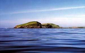 Rona, sometimes called South Rona to distinguish it from North Rona, is a small island in the Scottish Inner Hebrides, north of Raasay and northeast of Skye. It has a total area of around 3.5 square miles. In the nineteenth century the population of Rona fluctuated, and at its peak in 1881 it rose to 180. Many of these were crofting families which had been cleared from more fertile land on Raasay. In 1921, a group of men from the main settlement on Rona, Acairseid Thioram (Dry Harbour), landed on Raasay and attempted to re-occupy their ancestral land. These so-called 'Rona Raiders' were arrested and tried, but public support for them was strong and they were eventually freed and allowed to remain on Raasay. This led in 1922 to the acquisition of both Rona and Raasay from their private landlord by the British Government. After this, the population of Rona fell sharply, as most of the island's inhabitants followed the Raiders to settle on Raasay. By 1943 the island had become uninhabited, with the exception of two lighthouse keepers who lived at its north end until the lighthouse was automated in 1975. The ruins of Acairseid Thioram can still be seen, and are being restored to accommodate holidaymakers and archaeological and environmental working parties. In 1992 Rona was acquired from the government by a Danish owner, who restored Rona Lodge at Acarseid Mhor (Big Harbour), and built a new landing jetty. Rona currently has one permanent resident, the island manager, who lives at Rona Lodge (where B&B and bunkhouse accommodation are available), and who also manages the self-catering cottages at Acarseid Thioram. en.wikipedia.org/wiki/South_Rona
|
|
|
|
Post by andi on Feb 5, 2007 0:02:43 GMT 10
Small Isles
The Small Isles are a small archipelago of islands in the Inner Hebrides, off the west coast of Scotland. They lie south of Skye and north of Mull and Ardnamurchan – the most westerly point of mainland Scotland.
The four main islands are Canna, Rùm, Eigg and Muck. The largest is Rùm with an area of 105 km².
The islands now form part of Lochaber, in the Highland council area. Canna, Rùm and Muck were historically part of the counties of Argyll; Eigg was historically part of Inverness-shire until 1891, and all of the Small Isles were in Inverness-shire, from 1891 to 1975.
Smaller islands surrounding the main four include:
Sanday, near Canna
Eilean Chathastail, near Eigg and
Eilean nan Each (Horse Island), near north coast of Muck
There are also a number of skerries:
Hyskeir,
Garbh Sgeir,
Eagamol, near Eilean nan Each
Humla, and
two places called Dubh Sgeir
|
|
|
|
Post by andi on Feb 5, 2007 0:06:30 GMT 10
Canna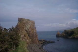 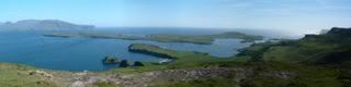 Canna (Gaelic Eilean Channaidh) is the westernmost of the Small Isles archipelago, in the Scottish Inner Hebrides. It is linked to the neighbouring island of Sanday by a bridge and by sandbanks at low tide. The island is 7 km long and 1.5 km wide. The isolated skerries of Hyskeir and Humla lie 10 km south west of the island. The islands were left to the National Trust of Scotland (NTS) by their previous owner, the Gaelic folklorist and scholar John Lorne Campbell in 1981, and are run as a farm and conservation area. Canna House, one of two big houses on the island (the other being Tighard), contains John Campbell's important archives of Gaelic materials that were donated with the islands to the nation. Campbell's widow, the American musician Margaret Fay Shaw, continued to live on Canna until her death in 2004 aged 101. Like Barra and South Uist, Canna has traditionally had a mostly Roman Catholic population; it was one of the few places to escape the Scottish Reformation. Population numbers remained fairly stable at around 20 - 30 during the second half of the last century, but by the time of the 2001 census had dwindled to 12. However, since the death of Margaret Fay Shaw the NTS has engaged in new initiatives to attract new residents and visitors to the island (see Call for families for Canna below). There are some 20 buildings on the island, including three churches (one is deconsecrated and is being converted into a study centre), a tea room and a post office (converted from a garden shed). The island is isolated and the inhabitants must buy their provisions from the mainland, but it has a telephone link, a red telephone box and broadband internet access, although there is no mobile phone coverage. Electricity is provided by a diesel generator, at mainland voltage and frequency, and there is a private water supply. The island has a zero crime rate - but a mainland-based policeman visits the island twice a year, mainly to inspect gun licences. A doctor based on the neighbouring island of Eigg is available for house calls once a month. The roads on Canna are not metalled and are privately owned, local vehicles therefore do not require road tax. The previous bridge to Sanday was destroyed by storms during 2005, and has recently been replaced by a road bridge. This allows vehicular access at all tide levels for the first time, although the road on Sanday is still covered by high tides. A large natural harbour is formed between Canna and Sanday. The pier on Canna, and those of the other Small Isles, was rebuilt and enlarged in 2005. This is used by the Caledonian MacBrayne ferry, MV Lochnevis, which links Canna, and the neighbouring Small Isles of Rùm, Eigg and Muck, to the mainland port of Mallaig (2 1/2 hours away). Lochnevis is capable of carrying motor vehicles, although NTS permission is required to land them. During the Summer months the islands are also served by Arisaig Marine's passenger ferry MV Sheerwater from Arisaig, 10 miles south of Mallaig. The harbour is well sheltered. It is the only deep harbour in the small isles, and is very popular with west coast yachting traffic out of Oban and Arisaig. Canna is renowned for its seabirds, including Manx shearwaters and puffins. The island is also inhabited by a number of rare butterfly species. In the nearby waters one can spot dolphins and smaller whales. Canna is noted for its tiers of basalt pillars that rise over the eastern half of the island and the sea cliffs that dominate its northern shore. The highest point on the island is Carn a' Ghaill (Gaelic for rocky hill of the storm) at 210 m. On the eastern edge of the island, Compass Hill (139 m) is formed of a volcanic rock known as tuff of such a high iron content that nearby ships' compasses are distorted, pointing east, rather than north. en.wikipedia.org/wiki/Canna%2C_Scotland
|
|